GIS ATMOSPHERIC & SOIL CORROSION MAPPING
Team Matergenics is one of the first companies to pioneer the integration of GIS mapping into the corrosion world. Others are trying to follow, however, Matergenics is at the forefront of this innovative technology. While the premise for this technology is rather simple the data collection and analysis are complex.
Why Matergenics?
Through its PhD research and previous work with customers, Matergenics has fine-tuned this technology to consistently develop accurate maps which its customers are able to use to maximize their corrosion mitigation resources.
The need to identify areas at higher risk for corrosion becomes more important as structures and coatings continue to age. However, a utility’s territory may cover thousands of square miles, and they may need to maximize limited resources to effectively manage its below-ground corrosion issues. The best way to address this situation is to develop a corrosion risk assessment map to identify areas of high corrosion risk. A corrosion risk assessment map will combine various properties of soil to identify areas of high, medium, and low soil corrosivity. With this map a utility company would be able to deploy its resources most efficiently to specific areas of identifiable high corrosion risk.

Above-grade and below-grade corrosion is of particular concern to aging, coated pipelines, water/wastewater and electric utility T&D in corrosive soils, as the aging structure will react with corrosive soil. This condition will result in loss in thickness. Stray AC current interference is another risk for pipelines. However, consider that zinc anode ribbons used for AC mitigation may exhibit accelerated corrosion in certain corrosive soils
analyzing properties
Our corrosion maps can be used for corrosion risk assessment, DC/AC interference risk and mitigation, identifying areas where shielding/coating disbondment can potentially cause localized corrosion, leaks, and possible explosions.
Soil Corrosion Mapping
The Technical Approach To Constructing A Below-Grade Corrosion Risk Map
Matergenics’ unique approach to soil mapping considers the following:
- Examination of spatial patterns associated with the physical and chemical properties of soil. This evaluation leads to insights on overall corrosion risk, and answers questions on where to locate a new pipeline and substation infrastructure.
- Identification of the least or most corrosive sites and possible sources of stray current for corrosion mitigation

Sources of Data
- Matergenics Soil Database
- Client’s Database (if available)
- United States Department of Agriculture
- Soil Survey Geographic Database (SSURGO) – the most detailed level of information for resource management, county planning, etc.
- National Resource Conservation Service

Soil Data Layers
Soil properties contributing to corrosion are individually mapped and a proprietary weighting system is used to compare the layers and develop an overall corrosion risk assessment map identifying areas of high, medium and low corrosion. A few of the properties are listed below. Field surveys are then made to confirm the accuracy of the map. The key to this technology is finding accurate data and the development of an accurate weighting system. Matergenics will also include maps for gas pipelines and transmission towers (if available), either of which may be a source for stray current corrosion.

Corrosion Risk Assessment Map
A proprietary method is utilized by Matergenics to create a final corrosion risk assessment map for the area of interest. The method includes an algorithm to assign a corrosivity index to each location on the map based on soil properties, geological data, and external corrosion factors. The accuracy of this algorithm has been field tested and proven in several projects.
Some Layers Incorporated into Corrosion Maps:
Soil properties play a crucial role in the overall corrosivity of soil. Physio-chemical properties describe the corrosivity of liquid phase in soil while the geological properties estimate moisture content and the ability of the soil to retain that moisture. Matergenics considers both to estimate corrosion risk. A few of the properties that are included in our corrosion maps are listed below.
SOIL RESISTIVITY |
ELECTRICAL CONDUCTIVITY |
|---|---|
SOIL TYPES, INCLUDING CLAY CONTENT |
DRAINAGE CHARACTERISTICS |
SOIL SALINITY |
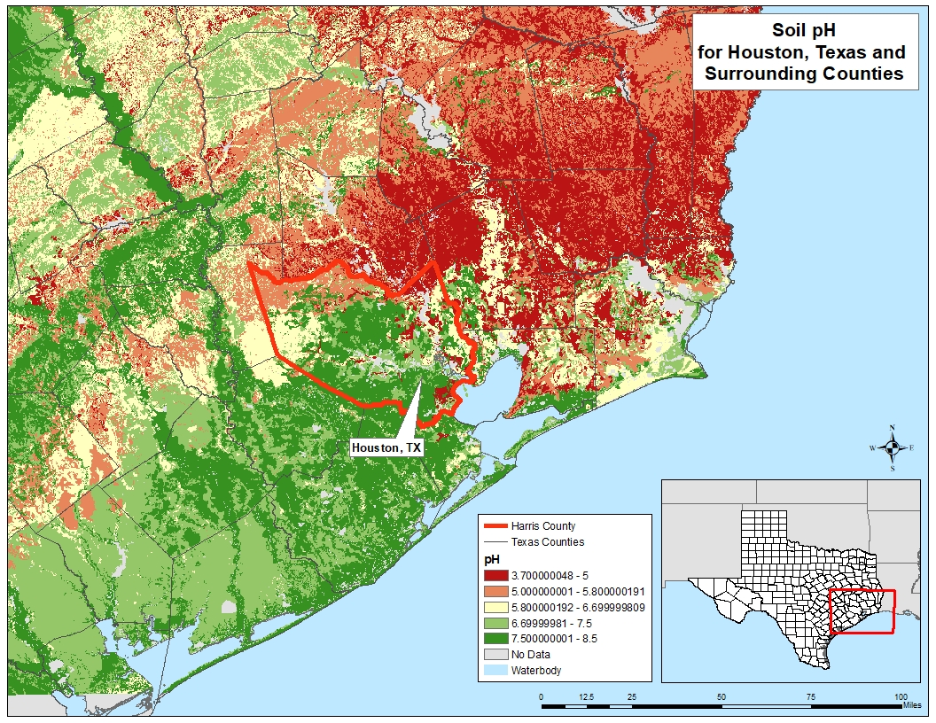
SOIL PH |
BULK DENSITY |
STRAY CURRENTS FROM NEARBY GAS PIPELINES |
Final Corrosion Risk Assessment Map
A proprietary method is utilized by Matergenics to create a final corrosion risk assessment map for the area of interest. Each soil data layer used in the analysis is assigned a weighting factor that corresponds to the level of importance in determining soil corrosivity. A final risk assessment map is produced, outlining areas of low, medium, and high corrosion risk potential. The accuracy of this algorithm has been field tested and proven in multiple projects.

Planning & Mitigation
Our corrosion maps can be used for corrosion risk assessment, materials and coating selection, as well as transmission line planning.
Atmospheric Corrosion Mapping
The Technical Approach To Constructing An Above-Grade Corrosion Risk Map
Matergenics’ unique approach to soil mapping considers the following:
- Examination of spatial patterns associated with the physical properties and aerosol deposition of the area of interest. This evaluation leads to insights on overall corrosion risk, and answers questions on where to locate new infrastructure.
- Identification of the least or most corrosive sites
Sources of Data
- Client’s Database (if available)
- National Atmospheric Deposition Program
- United States Department of Agriculture
- National Climatic Data Center
- National Oceanic and Atmospheric Administration

Atmospheric Data Layers
Atmospheric properties contributing to corrosion are individually mapped and a proprietary weighting system is used to compare the layers and develop an overall corrosion risk assessment map identifying areas of high, medium and low corrosion. A few of the properties are listed below. Field surveys are then made to confirm the accuracy of the map. The key to this technology is finding accurate data and the development of an accurate weighting system.
Atmospheric Corrosion Risk Assessment Map
Our assessment of atmospheric corrosivity is based on international standard ISO 9223. The classification is based on SO2 pollution, chloride deposition, and time of wetness. In addition to these properties, Matergenics also considers wind loads.
We monitor airborne salts carried by the wind from the ocean. Airborne chloride concentrations are not monitored by weather stations and the models that we use to determine them are only accurate up to a few miles from the shore. As such, most estimates using the model in conjunction with ISO 9223-1992 will be utilized for atmospheric corrosion maps.
Data Layers Used in Atmospheric Maps
Atmospheric aerosol deposition and wetness play a crucial role in the overall corrosivity of the environment. Our assessment of atmospheric corrosivity is based on international standard ISO 9223. However, in addition to the data used in the standard, we also consider other physical properties of the structure location. While not all of the following layers are used to produce the final corrosion map, an in-depth analysis can be conducted with the extra information.
SULFUR DIOXIDE DEPOSITION |
TIME OF WETNESS |
|---|---|
OXIDIZED NITROGEN |
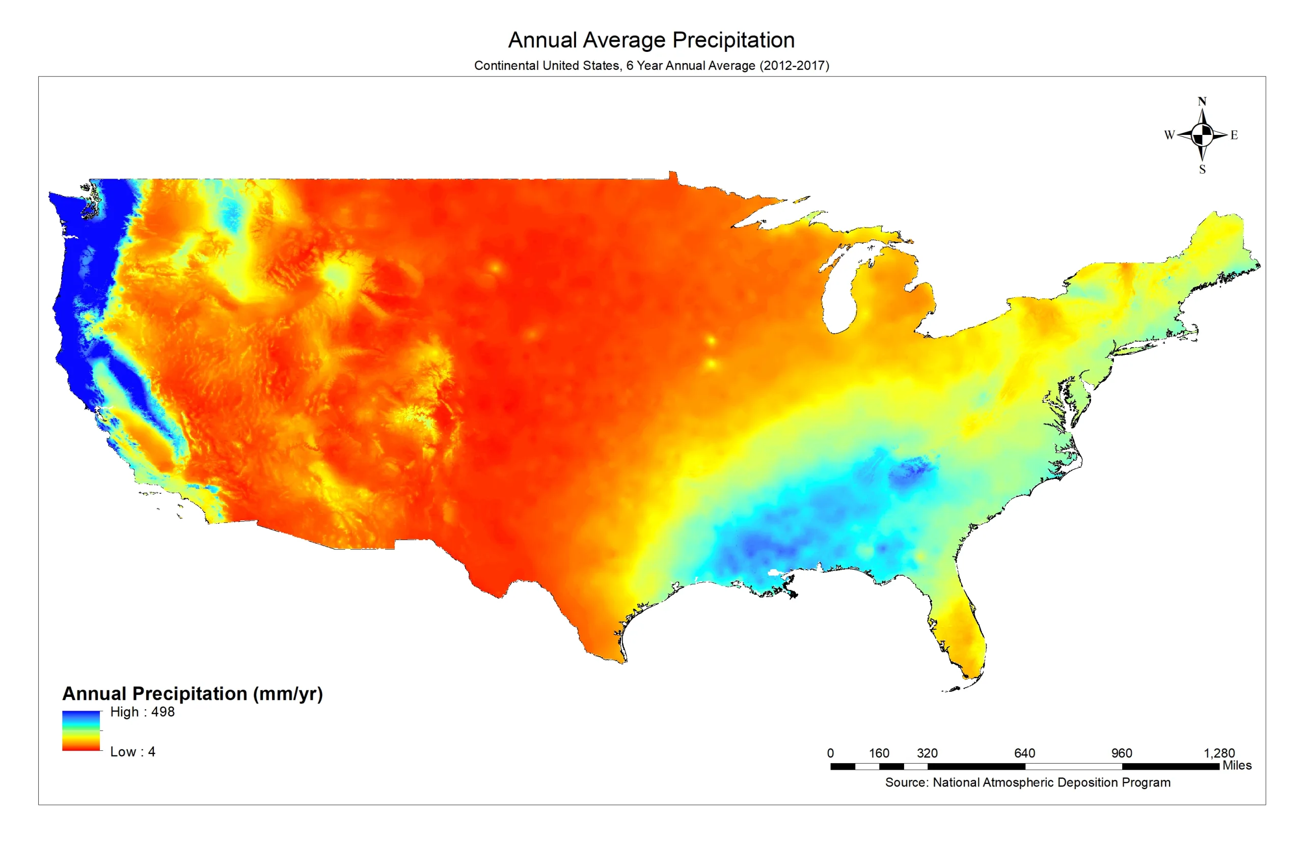
PRECIPITATION |
CHLORIDE DEPOSITION |
ELEVATION |
WIND SPEED AND DIRECTION |
RELATIVE HUMIDITY |
International Standard ISO 9223
ISO 9223 establishes a classification system for the corrosivity of atmospheric environments. Atmospheric corrosivity falls in one of five categories set by the standard. C1 represents rural environments and C5 represents marine atmospheres. The corrosivity category of the area of interest provides a basis for materials selection and protective measures with regards to specific application, particularly relating to service life.
The corrosion categories are based on the following three parameters:

DEPOSITION OF SULPHUR DIOXIDE
Sulfur dioxide plays an important role in atmospheric corrosion in urban and industrial areas. It is absorbed on metal surfaces, has a high solubility in water and tends to from sulfuric acid in the presence of moisture. Sulfate ions are formed in the surface moisture layer by the oxidation of SO2, and their formation is considered to be a corrosion accelerator.

AIRBORNE CHLORIDES
Chlorides are a major component of most salts, which accelerate corrosion due to their hydrophilic nature. When sat attracts water and dissociates, it produces a highly conductive electrolyte. Moreover, chlorides are a main catalyst for pitting corrosion, which is an auto catalytic, localized attack. Chlorides are known to cause hydrolysis and create acidic chlorides.

TIME OF WETNESS
Time of wetness is a measure of how much time the material will be in contact with a conducting solution. Wet surfaces are caused by factors such as dew, rainfall, melting snow, or high humidity. These conditions are estimated by looking at the time during which the relative humidity is greater than 80% and the temperature is above 0 degrees Celsius.
Atmospheric Corrosion Risk Assessment Map
A proprietary method is utilized in Matergenics’ corrosion risk assessment. This method includes an algorithm to weight each data layer and assign a corrosivity index to each location on the bap based on the atmospheric data, wind data, and corrosive gasses by chemical plants.
